Precipitation and Climate
Changing Precipitation
Precipitation on the North-East side of the Mt. Arrowsmith range, varies from an annual average of 200 cms in the high elevations, to 95 cms near the coast.
Generally the heaviest rainfall occurs during November and December near the coast, while highly variable snow pack amounts occur at higher elevations. Regional climate change is likely to result in lower snow levels in winter, earlier springs, warmer low humidity summers, and later drier fall
Climate Statistics
Average hours of sunshine - 2,047 hours annually
Average water temperature of ocean - 12°C
Average precipitation - 95 cm. annually
City Of Parksville Climate Statistics
Click the Drip
City of Parksville monthly rainfall
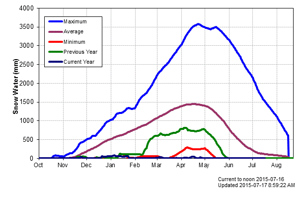
The Mountain Snowpack on Vancouver Island is very important to the overall hydrology. The seasonal snow melt can extend the surface runoff well into the summer months, maintaining river levels and groundwater recharge.
A wide variation of precipitation in this part of Vancouver Island.
Late November and December are typically the wettest months.
Summer months can have extended periods without rain.
This graph is the nearest to this area No. 3B23P at Jump Creek south-west of Nanaimo
This graph shows the variability of snow from year. Note the almost nonexistent snow pack for last winter 2014 - 15.


